|
America.
catalog
record
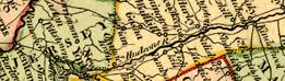
This small map, only 5 x 6 cm., is one of only four maps that
appear in a tiny pocket almanac, possibly owned by noted Restoration-era
scientist Robert Hooke (this attribution is based on the 17th-century
signature inside the cover). The map has little detail, but
its bright original coloring attracts the eye. Virginia is named,
and the Chesapeake region is seen in the wider American context. |
Middle Atlantic colonies and states on Western
Hemisphere maps are clearly placed in the context of their West
Indies trading partners and northern South American markets. The
hint of closer links to European nations is shown when Great Britain
and Ireland or Portugal and Spain peak over the edge of the map.
The way a mapmaker chooses to "project" the round earth
on flat paper means that various Western Hemisphere maps will display,
or not display, European coastlines.
|