 |
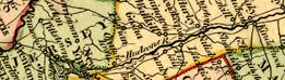
On this map of
the very young United States, we can still see the major Indian
tribes identified across much of the south and the "Western
Territory." Place names in the Middle Atlantic region are
almost totally "Anglicized." The Louisiana Territory,
in yellow at left, is only hinted at. The detail along the Missouri
River, just west of St. Louis, implies that some information
from Lewis & Clark's expedition, which had only begun in
1803, had reached this mapmaker in London. |
A new map of the United States
of America. 1806.
catalog
record |
|
 |
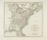
Here we see the
early outlines of the states prior to the Civil War. Note Virginia
in its earlier enhanced occupation of space. After the Civil
War, of course, West Virginia will appear on maps. Some early
maps of the United States spout their messages of patriotism
and independence with eagle and flag motifs. Another stroke
for independence from English control is the location of Longitude
0 degrees at Washington, D.C. rather than Greenwich, England. |
Map of the United
States, ca. 1828.
catalog
record |
|
For
further information on early mapping of North America, see
the following sites:
The
David Rumsey Map Collection
Hargrett
Rare Library Map Collection - Colonial America
To read about the early mapping of
America, examine The Mapping of America, by Seymour
I. Schwartz and Ralph E. Ehrenberg. 1980.
catalog
record
|
|